Cent cols in Triveneto
Introduction
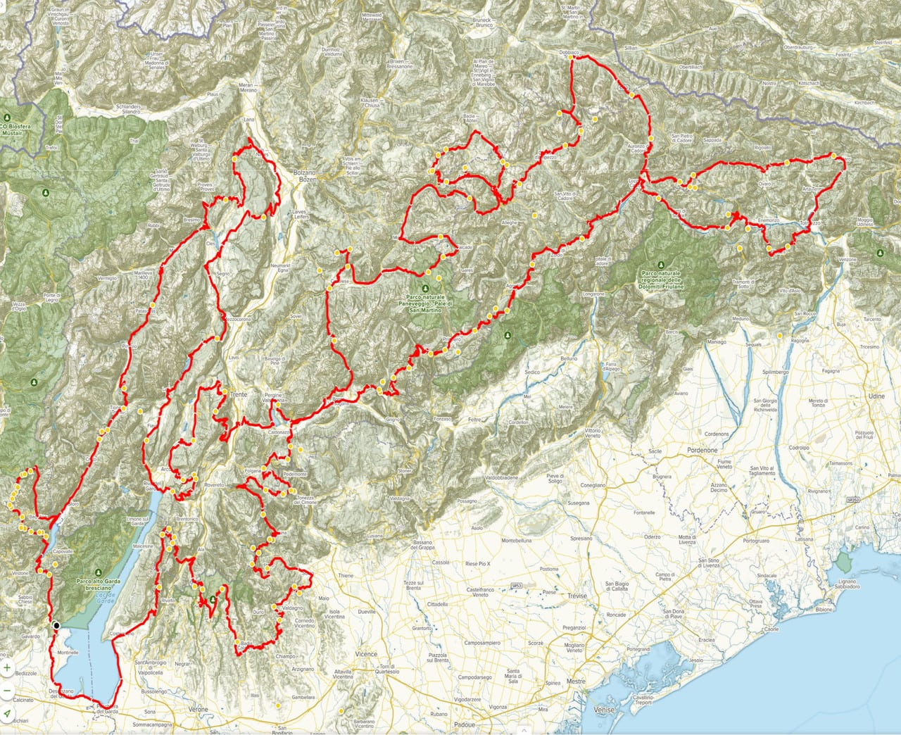
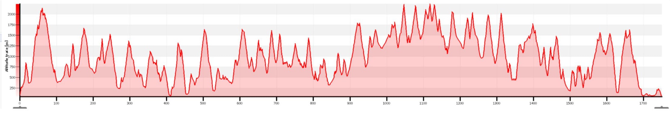
This 1,750 km circuit, including 100 passes for approximately 45,980 m of difference in height, designed by Gianni Solenni of the Confrérie des Cent Cols (member no. 3720) and has been updated and modified by Enrico Alberini (member no. 5065 ) and Gérard Birelli (member no.5553). It is located entirely in Italy, 90% of this route takes place in the three regions that make up Triveneto: Trentino – Alto Adige, Veneto and Friuli-Venezia Giulia. The circuit is almost entirely on surfaced roads.
Theme
The Club des Cent Cols, founded in 1972 and affiliated to the French Federation of Cyclotouring, has prepared this “Randonnée Permanente” based on a simple theme: “One Hundred Cols”. The completion of these one hundred cols will allow you either to join the Club, or to progress with your list in the Club’s “Tableau d’Honneur”.
Description and particulars of the regions
Although it begins on the Lombard shore of Lake Garda, 90% of this route takes place in the three regions that constitute what is known as the Triveneto: Trentino-Alto Adige, Veneto and Friuli-Venezia Giulia.
We set off from the locality of Salò, which was, for a brief historical period (September 1943 to April 1945), the capital of the Republic of Salò, on the shores of Lake Garda. We reach Vobarno by a very quietminor road, quite narrow, with some short passages at 13% or 14%. Then, at the entrance to the village of Eno, a country lane on the right leads out and back to the first col of the day, the Cocca. We then descent sharply to another lake, much smaller than Garda but just as beautiful, Lago d’Idro. It is worth stopping to admire it on the descent, before reaching the lakeside village of Idro.
We join the other shore at Tre Capitelli and pass through a lighted tunnel with openings overlooking the lake.
As soon as you exit Anfo, take a road to the left at the Passo Maniva sign where a series of cols begins which leads right to the foot of the imposing Adamello massif. The next descent brings you back to the shore of Lake Idro at a place called San Antonio. Again, it is worth stopping to admire the magnificent panorama.
We quickly leave the mountains of Lombardy to enter Trentino by following the Val Rendena. Madonna di Campiglio is one of the pearls of the Brenta Dolomites. This famous winter and summer resort is known among other things for the “Tre-Tre”, a track used for ski world cup competitions. We are in the western part of the Brenta massif and we skirt it to the north, crossing the Palade and Mendola cols in the northernmost part. In the eastern part of the massif, you pass through the localities of Andalo and Molveno, whose lake lies under the summits of Grostè, Brenta and Cima Tosa. Descending from the Passo Ballino, we find the north shore of Lake Garda, in Riva del Garde. From here, you climb the San Giovanni col and, following the signs, you face the Passo Santa Barbara with its murderous slopes of 14%, which were the scene of struggles during the Giro. We then climb another important summit, the Bondone with its many tourist resorts. This is also a fertile ground for cycle races (motorcycling too a few years ago). It is where Charly Gaul wrote one of the most famous pages in the history of cycling in the 1956 Giro.
After crossing the Val Lagarina, you discover other lakes that the route allows you to follow and admire: those of Caldonazzo and Levico, that are simply splendid. From Levico, an important spa resort, you can make a detour to Panarotta, a tourist resort located at 1800m above sea level. The riders of the Giro d’Italia took their chances on this course during a time trial. But, as you can imagine, there are many other races on these climbs. The climb to Panarotta is not planned on the route (optional).
We continue on the old main road (avoid the new one, it’s too busy) and we go east crossing several cols which for the first time bring us close to the Dolomites, unique in the world for their structure, their beauty and their majesty. When we look north from Fiera di Primerio, we see the Pale di San Martino range. We’llonly take a glance at it because the Passo Cereda is hard. Crossing it, you enter Veneto, in the region known as Agordino. Still heading north-east, we follow another interesting region, the Cadore, where we will return after having made a loop. Via the Passo della Mauria, you enter Friuli and follow for some time the SS 52, known as the Alemagna, an important highway dotted with numerous cols. A small out and back to climb the Col de la Pura allows us to see and appreciate Lake Sauris at an altitude of almost 1000m.
BE CAREFUL not to descend to the lake as the road to Ampezzo goes through a very long and dangerous tunnel.
In Ampezzo, we return for a short time on the SS 52. In fact in Prinso, we turn right to make another out and back to reach the Forca di Priuso. Back on the main road, our route turns right again, at the height of Preone, on the minor road to climb the Sella Chiampon and Chianzutan, before arriving in Tolmezzo, the main town of the Carnia region. From there you reach Paularo, climb the Forcella di Lius and descend to Paluzza, the birthplace of ski champion Manuela Di Centa.
From there, even if it is not included in the initial route, you can climb Monte Zoncolan, one of the most difficult climbs in Europe, from its easier side. But if you want to try the other side, the most difficult and the most famous, just follow the route up the Valcalda and descend directly to Comeglians, just 3 km from Ovaro, the starting point of the terrible Zoncolan.
The normal route continues through Val Pesarina which leads to ForcellaLavardet then to two other cols (Razzo and Rioda) from where one can once again admire Lake Sauris. If the weather allows, you can admire the enchanting panorama of lake, pastures, and peaks. We leave Friuli and return to Veneto. We are here on the eastern edge of the Dolomites. A few more climbs and we find ourselves in the heart of this splendid massif. Climbing the Passo di Tre Croci, you pass close to the famous Tre Cime di Lavaredo. In Misurina you can admire the peaks of the Cristallo, the Sorapiss, and the Croda Rossa. At Cortina d’Ampezzo, the Tofane mountain comes into view, and at its base liet he Passo di Falzarego and Passo di Valparola. Once more the super Dolomites at Corvara-in-Badia, the heart of the Dolomites,with its own language: Ladin. The Sassongher peak, the Sella range, and climbing the Passo Fedaia we find the region’s highest summit, the Marmolada … then, below and again the Dolomites: Sassolungo, Catinaccio, and the Vajolet Towers which are reached by a steep 6km climb. But there’s more. After climbing the Passo di Lavazè, in the Latemar range, you return, so to speak, not far from the Pale di San Martino in the Val di Fiemme. Leaving the Dolomites, we continue along the border between Veneto and Trentino, sometimes on one side, sometimes on the other. We climb the Passo Manghen on the ‘easier’ side… as it’s said, and we find ourselves at the bottom of Val Sugana via Levico. This town could act as a stopover since we pass there twice.
We follow the old road, now restored, that the Sultzen, Austrian soldiers, took to reach the front from their bases and we arrive on the plateau where was fought the Great War, and where it will not soon be forgotten. Each cemetary, each hill, each col and each valley was won several times, lost and retaken by the two opposing armies in a war of attrition. Many remains still witness today this great conflict and all its bloodshed and countless memories: trenches, forts, pillboxes, cemeteries. We can even see bomb craters.’Big Bertha’, the Austrian super cannon, although positioned near Lake Caldonazzo, fired its projectiles this far.
We climb the Passo de la Borcola and we re-enter Veneto to ride around Mont Pasubio, another defensive rampart beyond that of Mont Grappa. By mountain bike, you can reach the so-called “Italian Dent” (the southern peak: the Austrians held the northern), at the little col (a command post?) a sign jumps out at you: “Here, they shall not pass”. We ride out and back to Bocchetta Campiglia and its war memorial.
To return to our route, after Pasubio, we enter Lessinia, land of meadows and vineyards, with typical villages and cols which, although little known, are tough all the same. Watch out for the very steep descent of the Passo Fittanze della Sega which brings you back to Trentino. The climb from the Trentino side is one of the hardest in Italy. Now there is only Mount Baldo, a mountainous foothill which reaches 2000m all the same and which serves as a watershed between Garda and Val Lagarina.
After the beautiful tourist resort of (Col de) San Valentino, two more cols (Bocca di Creer little climb of the Passo del Casello and we arrive at Torri del Benaco on the east shore of the Lake Garda.
From there we return to Salò, the starting point by following the lakeside road for around 60km, passing through Garda, Bardolino, Peschiera del Garda, Sirmione (don’t miss the village on the lake) and Desenzano.
Original text by Gianni Solenni, translated from Italian by Jean-Paul Zuanon and Bernadette Barradi and modified by Enrico Alberini and Gérard Birelli.
Cols and points of interest
There are 15 optional cols which are of tourist interest but which have been removed from the main route to reduce the overall vertical climb. However, if the randonnée is done in several visits, they can be added. Traces are also provided.
- At point 1 the sign indicates on the right the Passo Cavallino Refuge at 4km. Via the SP from this crossroads, you reach the Passo Cavallino della Fobbia (1080m at 8.5km out and back). At the col, we turn left towards Cavaca and in 4 km we arrive at the crossroads of the SP 56 in Santellone;
- At the entrance of Roncone, we leave the SS 237 in the direction of Boca di Bodin (977m, 2.5 km there and back);
- From Tione via Zuclo you can climb the Passo Durone (985 m, about 14 km out and back);
- From Passo Mendola, it is possible to reach the summit of Monte Penegal, which offers a beautiful view of Bolzano and the Adige valley;
If you wish to stop at Bolzano in San Michele you can take the cycle path which passes through an old railway line with lit tunnels and through the Bolzano vineyard;
- Shortly after Predellano, take the SP on the left in the direction of Drio Silano which leads to the Forcella Brentana (1263m at 9.6 km out and back);
- At Imer-Mezzano go under the SS 50 and go up towards the Sforzelà del Zat (1222m at 5.25 km out and back);
- At Don Gosaldo we leave the SP 3 and take the SP347 on the left towards the Forcella Aurine (1296 m at 6.9 km there and back);
- At the Forca di Priuso it is possible to continue on the SS 552 until the Forca di Monte Rest (1061m, at 12.7 km out and back) by a succession of 9 hairpin bends;
- From Paluzza we descend to Sutrio and go up to Sella di Zoncolan (1740 m), this is the easiest side;
- From Comeglians, going down a few km to Ovaro, you can climb to Zoncolan by its steepest and best known slope;
- From Misurina, you can take the steep climb up to the foot of the fantastic Tre Cime di Lavaredo. In the last bend before the Auronzo Refuge, you reach the Forcella di Longeres (2248 m at 7km) by a path. This very hard climb offers a magnificent view of Lake Misurina and the Cadini range on arrival;
- After the Passo Giau a Caprile the SP 251 goes up to the Forcella di Staulanza (1771m at 9.8 km);
- Shortly before Paneveggio on the left the SS 50 leads to the Passo Rolle (1988m at 6.5km out and back);
- Shortly after Molina di Fiemme take the SS 48 on the right towards passo San Lugano (1097m 6.3 km there and back). The tunnel before San Lugano can be avoided by the old road;
- After Levico Terme in the direction of Monterovere the SS 349 goes to the left towards the Passo Vezzena (1414m at 3.5km out and back);
- From the Passo di Valbona, there is an asphalt track which, at 500m, leads to the Forcella Molon (1767m). This track is prohibited for cycling !!!
- From the Passo di Xomo a main road on the right leads to two neighbouring cols here: Bocchetta Campiglio (1207 m) and going down, halfway, we can clearly see on the left the Bocchetta del Xetele (1179m) accessible by a path of a hundred metres;
- At Prà Alpesina at the crossroads between the SP3 and the SP 230 take the left turn towards the Passo Pozza di Cola (1289m at 2.8 km);
Food and accommodation:
The circuit takes place almost entirely in tourist areas. So there are often restaurants, hotels, refreshments and inns. There should be no problem there. Here is a suggestion, however.
In Salò, the starting and ending point of the randonnée, the Italian members of the CCC organized their gathering a few years ago at the Hotel Panoramica. It can be a good base camp because we are now known there. The hotel is very good and so is the restaurant.
General Information
Report, Update
Thank you for sending us your appreciation on this Permanent Randonnée, whether this appreciation is positive … or it is less so.
Do not hesitate to report on your Hundred Cols Randonnée Permanente. This report may be submitted for publication in the Club des Cent Cols magazine or on the Club’s website (www.centcols.org/en).
Also, feel free to attach photos of your journey.
We are taking any information on any errors (distance, altitude) that you would have noted in our documents, as well as on any modification occurred on the route (change of numbering or state of the roads, prohibitions or creation of lanes …).
We also want to list the places of accommodation that we can recommend to other participants, thank you for sharing your experience.
Reference Documents
The cols mentioned in our documents meet our “Rules of the Game” (cols named on a document or a sign). The exhaustive list of cols can be found in the Catalogue of Italian Cols which is on sale at the Club des Cent Cols, see “boutique” on the Club’s website.
Mapping: the Atlas TCI maps are sufficient for this randonnée.
Internet page
All of this information will be placed on the “Randonnées Permanent” pages of the Club des Cent Cols website (www.centcols.org/en), as well as the list of registered / arrived members, including, if you authorize it, your full names.
And don’t forget to send postcards to the officer whose address is on the route map. Email address:
Controls
The participant must have his route card stamped at the start (Salo) and at each of the route points indicated above. Each stamp is in the form of either a wet pad requested from a merchant or an administration, or an explicit photo (eg bicycle in front of a commune or col sign). The 12 checkpoints are as follows:
- Salò: Obligatory stamp at the start
- Passo di Campo Carlo Magno
- Passo Mendola
- Valico di Monte bondone
- Passo Duran
- Sella Chianzutan
- Misurina
- Passo Pordoi
- Passo di Oclini
- Passo Pian delle Fugazze
- Bocca del Creer
- Peschiera del Garda
Cols more than 2000 m.
- Passo del Sella
- Passo Pordoi
- Passo Giau
- Passo di Valparola
- Giogo di Bala
- Passo Gardena
- Passo Falzarego
- Goletto di Crocette
- Passo Fedaia
- Passo di Rondendino
- Passo Manghen
- Passo di Valles
- Sella del Culac
- Goletto di Ravenola
- Sella d’Auccia
- Passo di Vaia
Rules of the randonnées permanentes
Any participant in this 100 Col Route agrees to respect the rules governing it.
More information
CONTACT:
Jean-Marc CLEMENT
10 rue de Normandie
31120 Portet sur Garonne
FRANCE
Tél : +33 (0)5 61 76 30 12
E-mail : randos@centcols.org