Pour la version française cliquez
ici: ![]()
Summary
For each of the 9,755 French passes,the Catalogue des Cols de France ("Le Chauvot") specifies its coordinates within a quadrant of a 1:100,100th IGN "TOP 100" map (blue covers), hereafter called "TOP 100". Quadrants are the rectangular subdivisions of these TOP 100's. These coordinates are given in millimetres along the horizontal and vertical axes of the quadrant. For example, the coordinates of Col du Galibier in the Chauvot are 54 3435 E 229-072. This means "TOP 100 # 54", "quadrant 3435", "Eastern half", "229 mm. from the left edge of the quadrant" and "72 mm. from the bottom edge of the quadrant". The Eastern half of quadrant # 3435 is called Half-quadrant 3436E. The Western half would be called 3436O ("O" being the abbreviation for "Ouest", West in French). This term and concept are the basis of the IGN Map Overlays.
An IGN Map Overlay ("Calque IGN" in French) is a graphical representation of all passes located on a half-quadrant. Over 600 half-quadrants are available. Some only include one pass, while some others have over 100.
To use an overlay, you first select and display a half-quadrant, then print it on a overhead projector transparency sheet. You then cut out the image of the overlay and overlay it on the corresponding half-quadrant on the map. Using this process you can either locate all passes along a pre-established itinerary, or design an itinerary that will take in the maximum number of passes.
Selection of the half-quadrant
You can use one of two methods to select a half-quadrant. The choice is personal, the result identical.
- Enter its number in the input box and press the Afficher (Display) button. Use this method when you already know the number of the half-quadrant.
- Select a TOP 100 from the overview map of France by clicking on its number. TOP 100's which do not contain passes will not be selectable. A selection table of half-quadrants containing passes on that TOP 100 will then be shown. Click on one of the table's cells to select the desired half-quadrant. To help you identify the half-quadrants in the table, the name of the corresponding quadrant (IGN "Orange Series" 1:50,000 map) will appear as your mouse goes over a cell. Half-quadrants are shown in pairs, and both halves will have the same name.
Printing and cutting
Once a half-quadrant is displayed, you need to print it and cut it so you can overlay it on top of the corresponding TOP 100's quadrant. Here are some printing tips:
- Overlays are designed to be printed on A4 size transparencies. Ensure your software uses magins of 1.25 cm. or 1/2" on all sides. If your margins are too wide you will cause the page to be split into two pages or the image will be cropped.
- Ensure that your software and your printer faithfully reproduce the original dimensions of the overlay's image. Try first with plain paper - much cheaper than transparency stock ! Each overlay is in PNG format and is 578 pixels wide by 760 pixels high at a resolution of 38 pixels per centimetre (96 DPI).
- Once you have printed the sheet, cut the overlay itself along the solid and dashed lines. The height of all overlays is 200.0 mm. The width varies with the latitude of the quadrant and the upper edge is always narrower than the lower edge. The dashed edge is a vertical line, while the other 'vertical' edge is a slightly slanted line, each quadrant being in fact a trapezoid. The exact dimensions are indicated on each individual overlay sheet. Also see the Geodesy and Projections paragraph below.
Legend
Each pass is represented on the overlay by an symbol indicating its difficulty level. This level is a simplified interpretation of what is in column 4 of the Chauvot. If you have the computerised Chauvot in Microsoft Excel format this simplified level can be found in the diff column. Please note that all "Surfaced road" passes are also shown on the Michelin Map Overlays.
Surfaced road Easy pushing Carrying Unrated road Unrated Cyclable Hard pushing Extreme Unrated path
The Chauvot Code of a pass is indicated as a label beside the pass' symbol (e.g. 34-0485). When the full Chauvot Code would overload and crowd the chart, the code is replaced by a 2-digit number (e.g. 05) and and index relating the number and the code is included in the margin. 2-digit numbering is used in overloaded areas and on all overlays containing more than 75 passes.
There are cases where there is not even enough space to place a 2-digit number
beside a pass. In those cases the label is placed elsewhere and a coloured line links the label to the pass symbol; the label, line and pass symbol are given the same colour. Different colours are used to differentiate separate label-line-symbol groups in crowded areas. The colours are for visual cueing only and do not impart any particular meaning to those passes.
Quadrants being fixed 0.40 gr. x 0.20 gr. areas, they are geography-centric, as opposed to map-centric, entities This means that each TOP 100 includes partial quadrants along its edges, and those quadrants continue on the neighbouring TOP 100(s). In addition, the majority of TOP 100's also overlap. This raises problems when trying to place overlays on these overlapping quadrants; unfortunately no magic solutions are available.
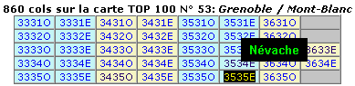
The selection table which displays all half-quadrants belonging to a given TOP 100 (see sample on the right) is divided into full quadrants. A pair of half-quadrants is said to 'belong' to a TOP 100 if one, or both, half-quadrants include passes located on this TOP 100 and even if the TOP 100 only includes a small sliver of those quadrants. In general you can ignore this whole issue; however in certain cases the number of passes shown for the TOP 100 will be smaller than the sum of the passes for each half-quadrant shown (see TOP 100 # 13). The accurate number for the TOP 100 is the one shown above the table (860 in the above example).
1:100,000th IGN TOP 100's use the Extended Lambert II projection for France. The use of this projection dictates that each 0.40 grades x 0.20 grades will have the same height (200 mm.) but different widths depending on the latitude (from 251.5 mm. for the Dunkirk quadrant to 301.0 mm. for the Bonifacio quadrant). Therefore, each quadrant is not a rectangle but a trapezoid whose lower edge is on average 0.9 mm. wider than its upper edge. The greatly exaggerated example on the right shows how half-quadrants are obtained by drawing a vertical line which bisects the trapezoid. This dashed line is also shown on each overlay. Please note that IGN maps use decimal angular divisions instead of base-60. 90 degrees = 100 grades.
The computer program which generates the overlays needs to know the exact dimensions of each quadrant in order to draw the passes' symbols at the correct location. While we know that each quadrant is theoretically 200 mm. high, we found a problem in determining the width: we attempted to measure the widths of each quadrant, but we found differences of up to 1.5 mm. on different copies of the same map depending on their physical condition (age, rough handling, exposure to rain, tears, taping, etc...). We therefore needed to determine the 'official' or 'ideal' width of each quadrant. In this respect the IGN was very useful and provided us with modified geodetic formulae for this purpose; in particular we would to thank Valérie Michel of the St.Mandé IGN office.
The 'official' full-quadrant widths which were used for drawing the overlays are shown in the following table (all widths in millimetres). Corresponding dimensions for a given half-quadrant are also shown on that half-quadrant's page. Dimensions on your particular maps may vary by +/- 1.5 mm. depending on their physical condition; so you can use the dimensions below as a guide.
Legalese: Please note that these widths were calculated by the Club des Cent Cols from IGN-provided formulas, but the widths themselves may not be recognised as 'official' by the IGN.
The lower width of a quadrant is always equal to the upper width of its Southern neighbour
Quad Top edge Bottom edge Quad Top edge Bottom edge Quad Top edge Bottom edge Quad Top edge Bottom edge xx16 264.37 265.28 xx31 278.09 279.01 xx46 291.83 292.75 xx02 252.53 252.45 xx17 265.28 266.20 xx32 279.01 279.92 xx47 292.75 293.66 xx03 252.45 253.37 xx18 266.20 267.11 xx33 279.92 280.84 xx48 293.66 294.58 xx04 253.37 254.29 xx19 267.11 268.03 xx34 280.84 281.75 xx49 294.58 285.50 xx05 254.29 255.20 xx20 268.03 268.94 xx35 281.75 282.67 xx50 285.50 296.41 xx06 255.20 256.12 xx21 268.94 269.86 xx36 282.67 283.59 xx51 296.41 297.33 xx07 256.12 257.04 xx22 269.86 270.77 xx37 283.59 284.50 xx52 297.33 298.25 xx08 257.04 257.95 xx23 270.77 271.69 xx38 284.50 285.42 xx53 298.25 299.17 xx09 257.95 258.87 xx24 271.69 272.60 xx39 285.42 286.33 xx54 299.17 300.09 xx10 258.87 259.79 xx25 272.60 273.52 xx40 286.33 287.25 xx55 300.09 301.01 xx11 259.79 260.70 xx26 273.52 274.43 xx41 287.25 288.16 xx56 301.01 301.92 xx12 260.70 261.62 xx27 274.43 275.35 xx42 288.16 289.08 xx13 261.62 262.53 xx28 275.35 276.26 xx43 289.08 290.00 xx14 262.53 263.45 xx29 276.26 277.18 xx44 290.00 290.91 xx15 263.45 264.37 xx30 277.18 278.09 xx45 290.91 291.83 For those of you who would be interested in those geodesy and map projections topics, the IGN provides literature on geodesy, coordinate systems and map projections. You can also browse this page on the theory of the geodetic system transformations used for the calculation of the above widths. Also see the details of various algorithms related to geodesy and map coordinate systems. All of the preceding documents are in French. In English, please see a description of conic projections, including the Lambert projection, from Wolfram Research. That site has many other links to related mathematical topics.
Data Source
These overlays were compiled from data contained in the computerised version of the Chauvot without modifying this data in any way. If there is a discrepancy between the actual coordinates of a pass and those shown on an overlay, then the same discrepancy exists betwen the Chauvot coordinates and the actual coordinates.
The name, elevation and other details about a given pass are located in the Chauvot. You can buy either the Printed Chauvot or the Computerised Chauvot (Microsoft Excel format). Please note that the computerised version includes other information that is not included in the printed version due to lack of space.
Updates
The IGN Map Overlays will be updated yearly after the publication of the final version of the yearly change records. Unlike the Michelin overlays, and because of the need to use different symbols for different difficulty levels, changes from one edition to the next will not be shown on the IGN overlays.
Miscellaneous
Fictititious quadrants. Some quadrants mentioned in the Chauvot have fictitious numbers. This means that these exist on the TOP 100's and are correctly located next to their neighbouring quadrants, but are not available from the IGN as an "Orange Map". These are quadrants which border either the sea or a neighbouring country, and which only include a small sliver of French territory; they are incorporated into neighbouring Orange maps. On the selection table these quadrants will be nameless (a small black rectangle will be displayed). These quadrants have the following numbers: 4354 4051 4052 4050 1246 3628 3629 1548 2550 3546 3447 3842.
Technical requirements. These IGN Map Overlays have been tested on the following browsers:
- Firefox 1.0, 1.5, 2.0
- Mozilla 1.4, 1.7
- Microsoft Internet Explorer 5.5, 6.0, 7.0
- Netscape 4.08, 4.5, 4.6, 6.0, 7.0
- Opera 7.0 (on Opera 6.0 Orange Map Name displays are disabled).
The display of Orange Map Names as you mouse over a cell in the selection table requires JavaScript. There are no other negative side-effects if your browser does not support JavaScript or if you have turned off JavaScript support.
Problems with Orange Map Name Displays. Some problems have been reported (e.g. large black blobs obscuring half the page) on some combinations of browser-operating system. If you experience this type of problem, please go to the browserinfo page and cut-and-paste the information that shows up in blue into an e-mail to the author, explaining the particulars of the problem. If possible, include screenshots which clearly highlight the symptoms experienced.
Other questions and comments ?
Please contact the author (English welcome)