The Col du Lautaret
Toponymy
The name of the Col du Lautaret (FR-05-2057) has a disputed origin. The name is thought to derive from :
- from autaret (from Latin altare - altar) a small hill on which sacrifices were made to the gods
- or more likely the pre-Indo-European radical aut expressing the idea of "height", "elevation", a root from which the Latin word allârealtar" and on the other, allaret, allare or autaretThe highest point of a path leading to a pass, a mountain pasture or a mountain.
Please note: the catalogue of French mountain passes includes 2 Le Lautaret passes and 4 Autaret passes.
Geographical location
Massifs
This is one of the lowest points on the ridgeline separating the Northern Alps and Southern Alpsbetween the Arves to the north and the Écrins massif to the south.
Geology
The Col du Lautaret is no exception to the rule in this sector of the Alps. Dissimilar geological strata lie side by side, happily overlapping each other as the Alpine uplift continues.
The distinctive feature of the Col du Lautaret is its mossy, rounded ridge, the result of the abrasive action of a glacier spreading into each of the two adjoining valleys. A moraine deposit at the bottom of the glacier has accentuated the flatness of the pass. Serre Orel, the small knoll to the south of the pass, is more resistant and has kept a more vigorous relief.
A large number of religious buildings in the Oisans, Guisane, Clarée, Haute Durance and Haute Romanche valleys were built using calcareous tuff with plants extracted from local tuffières, one of which can be found at the Col du Lautaret in the Jardin alpin. The tuffieres are so named because of the way they are formed by the interaction between limestone, water and plants.
Readers interested in this subject should refer to the comprehensive article by geol-alp.com
Hydrography
The Col du Lautaret is located on the watershed between the Isère basin and the Durance basin (both tributaries of the Rhône).
Visit Northern Alps (but facing west at the Col du Lautaret), the Romanche (a tributary of the Drac and then the Isère) rises to the south-west of the pass, at the Plate des Agneaux glacier in the northern part of the Écrins massif.
Visit Southern Alps, the Guisane (a tributary of the Durance) rises near the pass, to the south of it, on the northern slopes of the massif de Combeynot.
Access
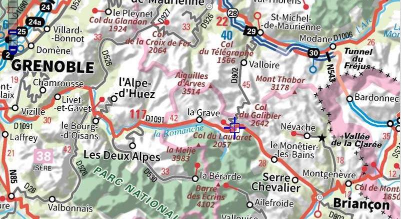
Western slopes (Northern Alps)
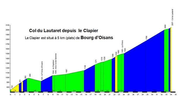
The N85 runs from Grenoble (90km, alt. 214m) to Vizille (72km, alt. 278m), then the D1091 to Bourg d'Oisans (40km, alt. 719m).
After Bourg d'Oisans, the 4.5 km-long straight stretch along the right bank of the Romanche leads to Le Clapier. At the eponymous dam, the D1091 climbs the Commères ramp, above the Infernet gorges.
Collective memory has it that the name "rampe des commères" ("gossip ramp") comes from the need for travellers to get off the stagecoach - so as not to wear out the horses - on this section of road, which was too steep. This forced walk loosened tongues, especially those of the ladies, who talked about everything and anything.
A more rational explanation is that the name comes from the presence of the Commères stream, which had to be channelled to make way for the road. For more details, click here:
https://freneydoisans.com/freneytique/mystere-de-la-rampe-des-commeres/
The road then leads to the Chambon dam (25 km away, alt. 1040 m), and crosses the Isère / Hautes-Alpes border 19 km from the pass (alt. 1134 m) before crossing La Grave (11 km away, alt.1526 m).
South-East slope (Southern Alps)
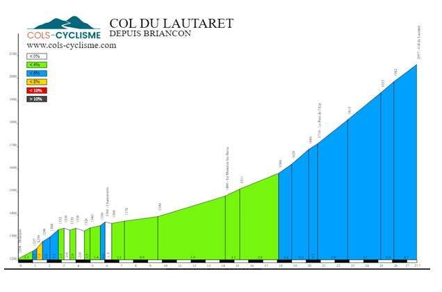
From Briançon (27 km away, alt. 1215 m) the D1091 leads to the Col du Lautaret, passing through the resort of Serre-Chevalier and its various villages: Chantemerle (commune of St Chaffrey - 22.5 km away, alt. 1350m), Villeneuve (commune of La Salle-les-Alpes, 19 km away, alt. 1385), Monetier les Bains (13 km away, alt.1500 m).
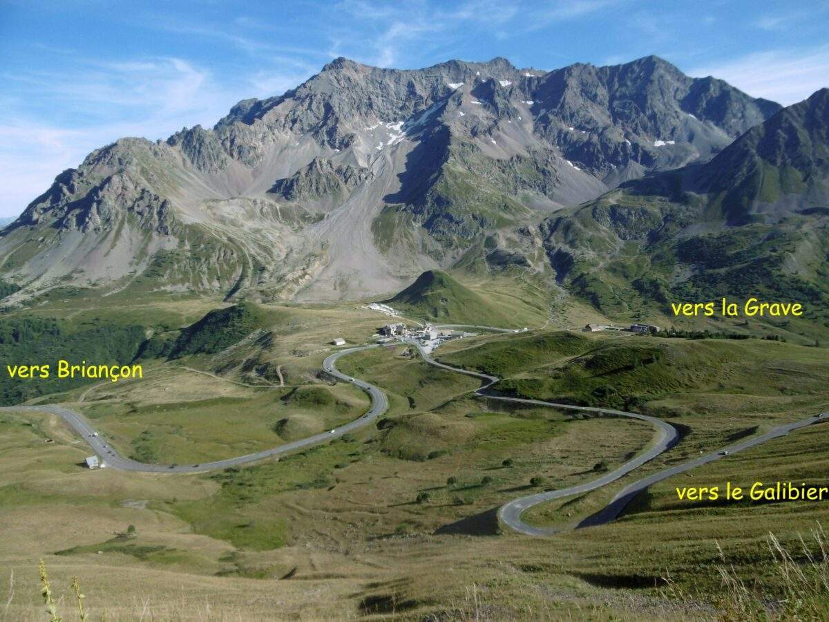
Access from the Galibier
From the Col du Galibier (2642 m) to the Col du Lautaret (2057 m), 8.7 km downhill on the D1091 (average gradient 6.7 %).
Changes to access
Western slopes (Northern Alps)
This route through the Alps was preceded by several other traffic routes, including a Roman road linking Grenoble to Briançon in Antiquity and, centuries later, the road from Grenoble to Briançon, also known as the Petite Route de l'Oisans, then the Route Impériale no 110 at the beginning of the nineteenth centurye century. Their layouts were not identical, but broadly similar.
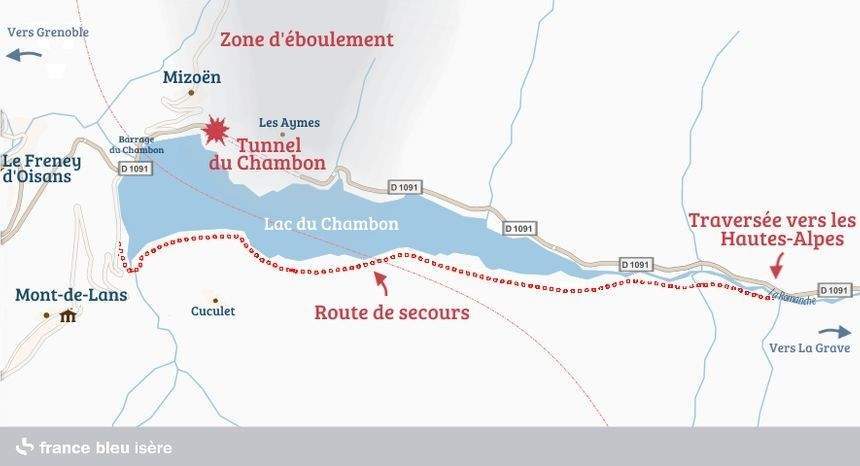
Before the creation of Chambon dam (impounded in 1935), the road ran along the valley floor. As the reservoir had the effect of drowning this area, a new route was chosen for the road, which passed over the top of the dam before skirting the north side of the lake, passing by the Chambon tunnel.
On 10 April 2015, the Chambon tunnel is completely closed to traffic, because of thelandslides and landslides which weakened the structure. As a result, the D1091 is completely cut off, causing major traffic problems in the valley for local residents as well as for professionals and tourists who use the road. emergency road (RS 1091) was opened on the left bank of the lake on 24 November 2015. It was used by the BRA in 2017 (by obligation) and in 2019 (when the new tunnel was inaugurated by the Isère département). A green route since 2020, it was used in 2023 to avoid the 990 m long tunnel.
Western slopes (Northern Alps)
Towards the Galibier
The current road dates back to 1936.
For a history of changes to the road, see Lucien Chevalier's article : A history of the Galibier pass road.
What to see - tourism
Western slopes (Northern Alps)
The Chambon dam
Construction work began in September 1929 and was completed in December 1935.

Since 2003, it has been awarded the "Isère's 20th-century heritage site.
After 80 years of existence, the dam has fallen victim to the alkali-reaction phenomenon (concrete disease), and every fifteen years it has to undergo special treatment. For this reason, replacement of the dam is planned within the next twenty years.
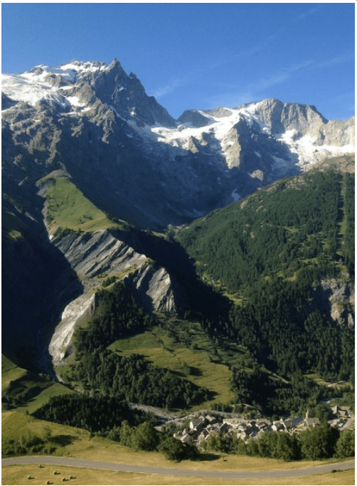
La Grave
- The internationally renowned Vallons de la Meije off-piste skiing area.
- Religious complex comprising the parish church, a chapel and the cemetery, at La Grave, listed as a historic monument since 1959. This complex includes the'Notre-Dame-de-l'Assomption churchoriginally dating from the XIe It is in the Lombard Romanesque style and was rebuilt or modified in the 15th and 16th centuries.eXVIIe and XIXe centuries. Also part of the religious complex: the cemetery surrounding the church and the Chapel of the White Penitents.
Villar-d'Arêne
The traditional baking of bread still takes place in the communal oven building for a few days a year, particularly on the 3rd of July.e weekend in November, with the making of "boiled bread".
South-eastern slopes (Southern Alps)
- Serre-Chevalier ski resort
- The Grands Bains du Monetier Located in the heart of the Serre-Chevalier ski resort in the Southern Alps, the Grands Bains du Monêtier SPA benefits from naturally hot water that gushes out of the spring at a temperature of 44°C.
- Le Casset (commune of Monétier-les Bains). Visit Ecrins National Park Visitor Centre screenings, workshops, meetings with a warden, etc.
At the pass
The Alpine resort Joseph-Fourier is part of Grenoble-Alpes University and the CNRS. It comprises three units, two of which are located at the Col du Lautaret:
- the chalet-laboratory at Le Lautaret ;
- the Le Lautaret alpine botanical garden (which is also a listed site);
- l'Robert Ruffier-Lanche arboretum (on the Saint-Martin d'Hères campus).
The botanical garden features plants from the Col du Lautaret region and from other mountains around the world. The garden's collections include more than 2,000 species. The garden is set in a natural environment that is itself characterised by specific climatic conditions and a high level of biodiversity. Various scientific studies have been and are being carried out in the area, in conjunction with the Joseph-Fourier alpine station and other scientific research bodies. Visit Cahiers illustrés du Lautaret are an example of how work carried out in connection with this station can be made available to the public in the form of published documents.
Since 2016, the facilities on the Col du Lautaret have been complemented by the Galerie de l'Alpe, a building better suited to the Alpine resort's public reception, research and training activities than the existing chalets.
Please note:
- before being on the Col du Lautaret, the alpine garden was in Villar-d'Arêne (a little above the village on the way to the foot of the pass)
- with global warming, experimental plantations are being planted on the slopes of the Galibier above 2400 m .....
La Chapel of the Fused Perched on the summit of the Col du Lautaret, a chapel has been erected in memory of several victims of the Second World War.
At the beginning of August 1944, a column of retreating German soldiers struggled from Briançon towards Grenoble. Harassed by Resistance fighters, they sowed death along the way. On 11 August, seventeen Resistance fighters were executed at the Col du Lautaret. On the same day, the Germans took all the male inhabitants of Villar-d'Arêne hostage. Six hostages and a German soldier died in a mine explosion under the Chambon tunnel. On 14 and 15 August 1944, the Nazis executed Jews, Resistance fighters and hostages in Bourg-d'Oisans, before continuing on to Grenoble.
Administrative status
Currently
The pass marks the boundary between two communes in the Hautes-Alpes department Villar-d'Arêne and Monêtier-les-Bains.
History
Both sides of the Col du Lautaret are in the Hautes-Alpes département.
Why doesn't the boundary between the Isère and Hautes-Alpes departments coincide with the Isère / Durance LPE at the Col du Lautaret pass?
When the department was created, in 1790, the communes of La Grave and Villar-d'Arêne (val de Romanche) demanded that they be attached to the Hautes-Alpes (and not to Isère) because they hoped to benefit from the advantageous status of the Escartons of the Briançonnais.
Until 1790, both sides of the Col du Lautaret were part of the Dauphiné Province, but since 1790 they have been part of the Hautes-Alpes département.
Cycling and cycle tourism
The Col du Lautaret is a "great classic" on the route of the Galibier pass All cycling events (Tour de France, Critérium du Dauphiné) and cycle tours (Marmotte, BRA) pass through here.
Profile
There are many profiles on the internet.
For example, those copied on the cols-cycling website show that there are no "severe" sections on the ascent of Le Lautaret.
An article by Gérard Galland
with contributions from Jules Arnaud and
Bernard Giraudeau (for the geology section)