The Col du Coq
Col du Coq FR-38-1434
Toponymy
According to Wikipedia: The name «Coq» derives from the Old French noun ‘cuchet’, which in turn comes from the Gaulish word ‘kukka’, meaning a rounded peak. It is therefore unrelated to the presence of the black grouse or capercaillie.
Geographical location
Massif
The Col du Coq is situated in the Chartreuse Mountains, to the east of the north-south valley that runs through the range, featuring the three passes: Granier (FR-73-1134), Cucheron (FR-38-1139) and Porte (FR-38-1326b).
It is the highest road pass in the Chartreuse Mountains.
Topography
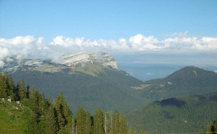
As shown in the illustration above, the Col du Coq is flanked by the following peaks:
- to the north-east lies the Dent de Crolles (2,062 m), to which it provides the main access route via the Col des Ayes,
- to the north, Mount Pravouta (1,760 m), which can also be reached via the Col des Ayes,
- to the south, the Bec Charvet (1,778 m).
Further to the south-east lies the summit of Chamechaude, to the east of the Col de Porte.
The Chartreuse massif forms a bastion isolated from the rest of the Alps. As a result, Chamechaude, its highest peak, happens to be the 3rde the most prominent peak in mainland France after Mont Blanc and the Barre des Écrins, rising slightly higher than the Pointe d’Arcalod in the neighbouring Bauges massif. See. Wikipedia.
Geology
Like bad pupils – and so as not to repeat what is written in the article on the Col de Porte, and the reference to that article for those of the Cucheron Pass and the Granier Pass – we asked the AI: « What can be said about the geology of the Col du Coq? »Here is the answer:
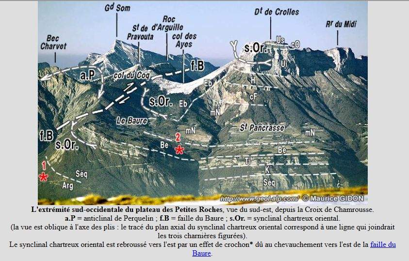
Le Col du Coq (1,434 m), situated in the Chartreuse massif in Isère, is a site of exceptional geological interest. It is a textbook example for geologists as it lies at the junction of several major tectonic structures in the massif, wedged between the Pravouta dome, the Bec Charvet and the immense wall of the Dent de Crolles.
Here is what can be said about the geology of the Col du Coq:
- The nature of the rocks: the subalpine alternation
Like the rest of the Chartreuse, the landscape around the pass is shaped by sedimentary rocks of marine origin (deposited during the Mesozoic era, particularly in the Cretaceous period). A typical alternation can be observed here:
– hard limestones (such as the Urgonian) : they form the impressive, sheer cliffs of the Dent de Crolles just above the pass.
– marls and marl-limestones : being softer and impermeable, these rocks erode easily. It is precisely the erosion of these marl layers that has carved out the pass and led to the formation of the lush mountain pastures of Pravouta. - Tectonic complexity: the collision of tectonic plates
The Col du Coq is not merely a series of horizontal rock layers; it is the result of intense tectonic «collision» during the formation of the Alps. At the pass, two forces are at work:
– the Perquelin anticline : the Pravouta ridge, which overlooks the pass, forms the eastern flank of this large fold in the rock.
– a network of thrust faults and normal faults : This sector is an area of major compression. Here, we can observe the overlap between the Bec Charvet (which is pushing westwards) and, conversely, the Manival and Baure structures (which are pushing eastwards). The pass is literally situated at the point where these rock blocks meet and come into contact.
Did you know? Right at the pass itself (particularly along the educational trail in the Sensitive Natural Area), one can observe remarkable tectonic microstructures, such as schistosity planes and micro-faults, which bear witness to the compressive force that raised the Alps. - The legacy of the Quaternary glaciations
During the last ice ages (such as the Würm), the Col du Coq served as glacial diffluence threshold. The immense Alpine glaciers that once covered the Grésivaudan valley were so thick that they overflowed and crossed the pass to flow into the heart of the Chartreuse (the Saint-Pierre-de-Chartreuse valley).
This repeated glacial activity has helped to smooth out the pass’s terrain and leave behind glacial deposits (moraines), which can be found beneath the vegetation of the mountain pastures.
Hydrography
- To the east, on the Grésivaudan side, the Ruisseau des Meunières has its source at the Col des Ayes (FR-38-1538) and flows close to the Col du Coq. Where it joins the Gorgette stream, it takes the name of Craponoz, then leaves the Petites Roches plateau via the Craponoz waterfall and joins the River Isère a little downstream from the Brignoud bridge.
- To the west, the maps do not show any streams that have their source near the Col du Coq.
Further down flows the Orme stream, which joins the Herbetant stream – a tributary of the Corbelliers stream – which flows into the Guiers Mort at La Diat.
The Guiers Mort and the Guiers Vif converge at Entre-deux-Guiers to form the Guiers which flows into the Rhône downstream of Saint-Genix-sur-Guiers (Savoie).
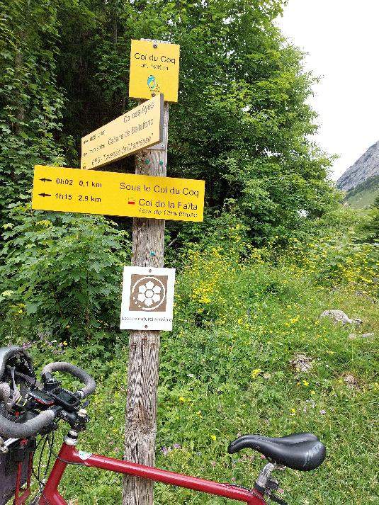
Access
East-facing slope
The D30 starts from the D1090 at Les Eymes – in the municipality of Saint-Nazaire-les-Eymes and rises up the eastern slope of the Chartreuse massif. After the tunnel and 7 km, you pass the D30 on your right, which leads to Saint-Pancrasse, Saint-Hilaire and the Petites Roches Plateau. From the crossroads, it is 5.5 km to the Col du Coq.
Western slope
Coming from the Col de Porte From the D512, the D57b begins after a 4.5 km descent.
Taking the D57b, you pass through Cherlieu after 1.2 km, then Saint-Hugues-de-Chartreuse (3.2 km). In Saint-Hugues, the «route de Gérentière» on the right, which becomes the «route du Col du Coq», leads to the pass (12.8 km from the D512/D57b junction).
Administrative status
The Col du Coq is situated on the western boundary of the municipality of Saint-Pierre-de-Chartreuse and is part of the former municipality of Saint Pancras which, in 2019, merged with neighbouring municipalities to form the municipality of Plateau-des-Petites-Roches.
History
Remains of the Habert des Ayes, to the north-east of the pass, about one kilometre away, towards the Dent de Crolles.
Although modest, the remains of the Habert des Ayes – now situated within the Col du Coq Sensitive Natural Area and the Hauts de Chartreuse Nature Reserve – bear witness, like the Habert de Pravouta, to the thousand-year history of the Chartreuse mountain pastures, the major role played by monastic orders in the development of the Carthusian agro-sylvo-pastoral economy since the Middle Ages, and a farming system dedicated to cheese production that endured until the early 1960s.
In 2004, the Isère Department acquired the Ayes ruins and the surrounding plots of land, and the Col du Coq–Pravouta Sensitive Natural Area was established. Finally, in autumn 2020, the remains of the habert, which were in danger of collapsing, were secured and stabilised (an information panel has been placed on the building).
Ski
The Col du Coq had a small ski resort which opened in 1967. It consisted of three ski lifts: the Chalet lift, the Prairie lift and the Bec Charvet lift. Following disputes between the owner and the operator of the ski area, the facilities were left to fall into disrepair from 1995 onwards. In 2012, the Mountain Wilderness association, with the help of volunteers, dismantled the disused lifts.
What to see - tourism
Sensitive Natural Area
The Col du Coq is one of around 140 Sensitive Natural Areas in the Isère department.
The Col du Coq Sensitive Natural Area is a departmental-level mid-mountain Sensitive Natural Area characterised by its meadows, beech and fir forests, cliffs and scree slopes. The black grouse is a threatened species, and its population is being monitored.
In Saint-Hugues-de-Chartreuse
The church of Saint-Hugues-de-Chartreuse houses the Arcabas museum in Chartreuse dedicated to the artist’s work (111 works of contemporary sacred art).
Cycling and cycle tourism
Cycling tourism
As far as I can recall, as a cycle tourist from Grenoble, there have been no cycle rides or brevets organised by local clubs that have taken the Col du Coq.
Tour de France
The Tour de France took the Col du Coq, a Category 1 climbre category, at the 17the stage in 1984 between Grenoble and L’Alpe-d’Huez, and then during the 20the stage in 1987 between Villard-de-Lans and L’Alpe-d’Huez.
Profile
Both sides of the pass involve «steep climbs».
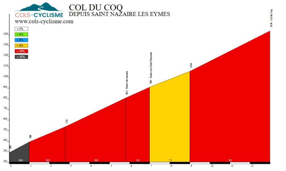
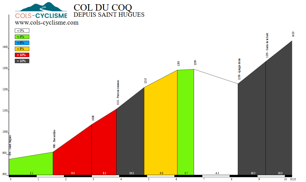
According to Cols-Cyclisme.com :
- From the east, from Saint-Nazaire-les-Eymes, the climb – as shown in the graph below – is steady throughout the 13 km.
- Via the western slope and Saint-Hugues, the climb is very uneven, with two particularly tough sections, the first at 4e kilometre, and the second after a short descent for the final two kilometres.
| From Saint-Nazaire-les-Eymes | From Saint-Hugues-de-Chartreuse | ||
|---|---|---|---|
| Length | 13.00 km | Length | 10.25 km |
| Elevation gain | 1,146 metres | Elevation gain | 559 m |
| Average % | 8,82 % | Average % | 5.45 % |
| Maximum % | 12,0 % | Maximum % | 16,0 % |