Col du Granier
An article by Gérard Galland and Christian Jeandey.
Col du Granier (FR-73-1134)
Photo Sébastien Vadot (image on the Club des Cent Cols pass viewer).

Photo Jean-Luc Matte (image on the Club des Cent Cols pass viewer).
Toponymy
According to Wikipedia, the name Granier derives from the Old French «granier, grenier» or «grange» (from Latin granea). It is the name of a municipality in the small Marche region, where there was a monastery. monachi Graneriis (Granarium, Granerium) - referred to in XIe century in the Cartulaires de l'église cathédrale de Grenoble dits Cartulaires de Saint-Hugues, It was destroyed by a landslide in 1248. The name was then transferred to the mountain.
Geographical location
Massif
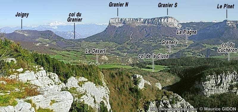
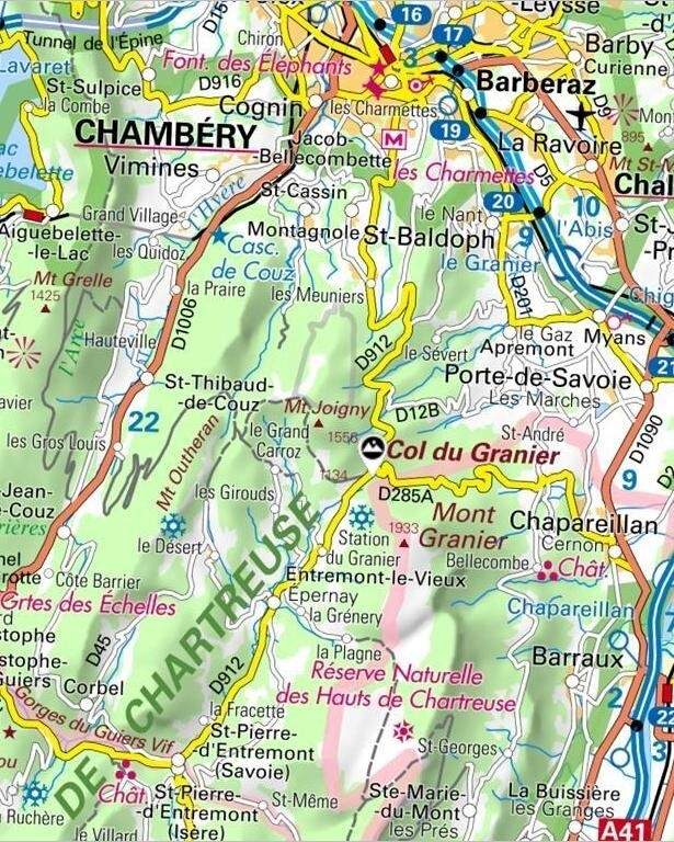
The Chartreuse massif is crossed by a depression from north to south. There are three passes in this massif, the Col du Granier being the one furthest north of the depression. The other two passes in the Chartreuse are the Col du Cucheron (FR-38-1139) in the centre of the massif and the Col de Porte (FR-38-1326b) the furthest south. The Col du Granier lies between Mont Granier to the south-east and the Pointe de la Bornée to the north-west. The following two images, taken from the website geol-alp by Maurice Gidon, This is a perfect illustration of the position of the Col du Granier at the foot of the mountain of the same name.
Geology
Please refer to the specific article on « Col de Porte »Discover the geology of the Chartreuse massif.
And for specialists, you can find more details at the following link:
http://www.geol-alp.com/chartreuse/6_sites_ch/col_granier.html
Hydrography
To the north, the’Albanne and several of its tributaries, such as the torrent des Favières and the ruisseau de la Grenouille, have their sources to the north of the pass.
The Albanne is a left-hand tributary of the the Leysse. It is therefore a sub-tributary of the Rhône via Lac du Bourget and the Savières canal.
To the south is the Ruisseau des Pins, which rises near the Col du Granier. It is a tributary of the Cozon river, which has its source to the west of the pass not far from the pointe de la Gorgeat. The Cozon in turn becomes a tributary when it flows into the Guiers Vif near Saint-Pierre-d'Entremont.
Access
The pass is crossed from north to south by the D912 between Chambéry and Saint-Pierre-d'Entremont.
Between Chambéry and the pass, the D912 passes through the Pas de la Fosse tunnel (FR-73-0822) located under the Pas de la Fosse pass (FR-73-0865).
Coming from the east and Chapareillan, We're on the D285, which joins the D912 at the pass.
The pass links the villages of’Entremont-le-Vieux south to Apremont to the north and Chapareillan to the east.
Administrative status
The pass is located in the south-west of the Savoie department, in the commune of Apremont.
History
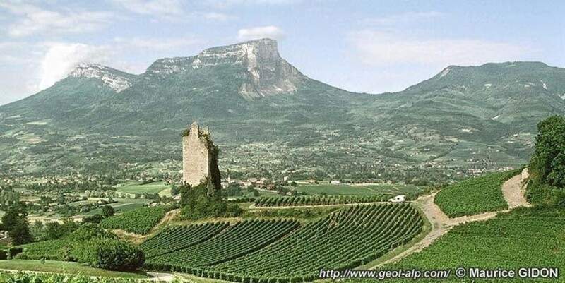
The north face of Mont Granier is a cliff almost 900 m high. This cliff was created on the night of 24-25 November 1248 following a gigantic landslide that wiped out part of the mountain. It is probably the largest known landslide in the history of Europe.
What to see - tourism
South side
North side
Le Bauges massif, the city of Chambéry and the Lac du Bourget.
Cycling and cycle tourism
Chartreuse Ramblers' Certificate (BRC) See article « Col de Porte ".
Different Profiles
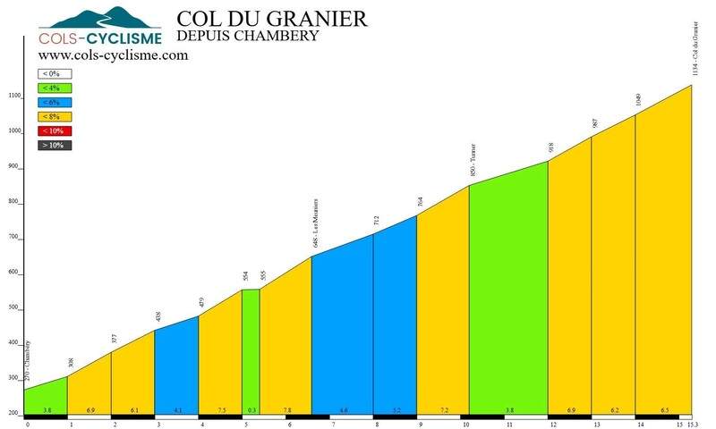
Ascent from Chambéry
The fifteen-kilometre climb from Chambéry does not present any major difficulties.
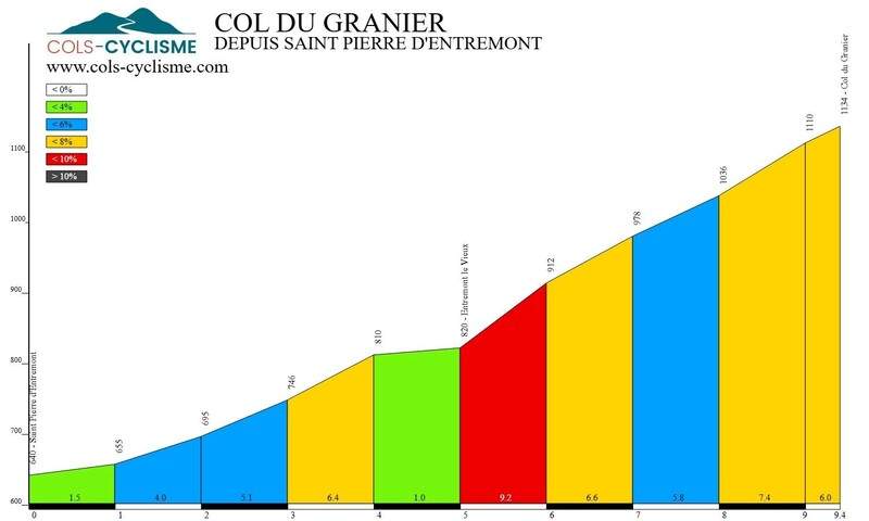
Ascent from Saint-Pierre-d'Entremont
From Saint-Pierre-d'Entremont, the climb starts at 640 m and is 9.4 km long. Be careful: it's a fairly steep 1 km from the village of Saint-Pierre-d'Entremont. Entremont-le-Vieux.
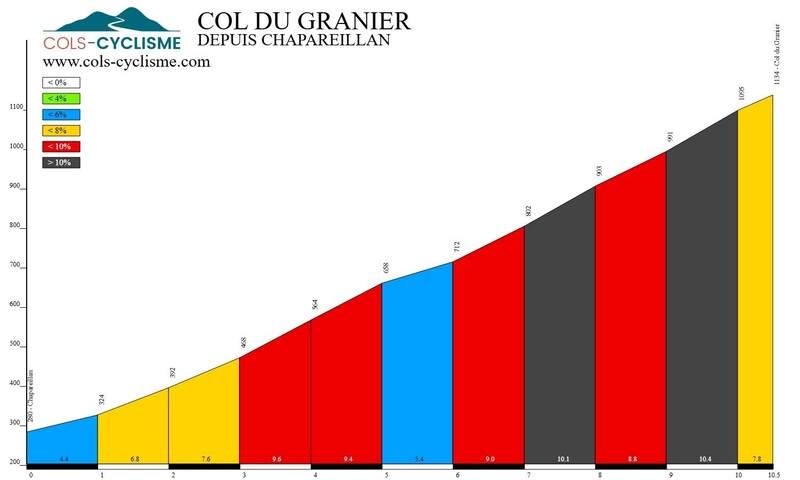
Ascent from Chapareillan
The steepest of the three climbs, with 854m of elevation gain in 10.5km and sections at 10.4 %.