The sign war
When you cross the Pyrenees to explore the passes of our Spanish neighbours, you are often surprised by the differences between the data provided by the map and that provided by the pass signs or the altimeter. You have a choice of three different altitudes, some of them very different.
Wouldn't a metre have the same length in Spain? An explanation can be found in the example of the Col d'Ares (FR-66-1513 or ES-GI-1513), a border pass above Prats-de-Mollo-la-Preste. What do the signs on the French side and the Spanish side indicate?
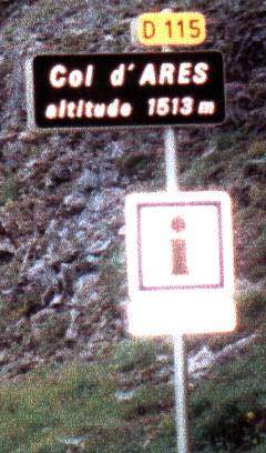
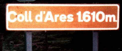
Clearly the French DDE and the Spanish DDE don't measure altitudes in the same way. A ninety-seven metre difference in the altitude of the same pass is quite considerable! So who's right? We need a referee: Mr IGN...

The map shows Col d'Ares at 1512m. Within a metre, this is the same altitude as that shown on the French sign. That's perfect. Where does the altitude of 1610m on the Spanish sign come from? Quite simply from Mont Falgars, which dominates the Col d'Ares to the south at 1611m!
So, when you cross the border, please leave your Cartesian mind at customs, where a sign indicates the altitude of the place where it is placed. After all, a little fantasy is not unpleasant...
Text and photo credits: René POTY